Category Archives: Uncategorized

SCCOOS News Just Released
Tuesday, April 08, 2025 - 12:00amCheck out what we have been up to

Apr 10 San Diego MPA Collaborative Mtg At Tijuana River Estuary
Tuesday, April 01, 2025 - 12:00amAgendaZoom – Mtg ID 880 470 6747
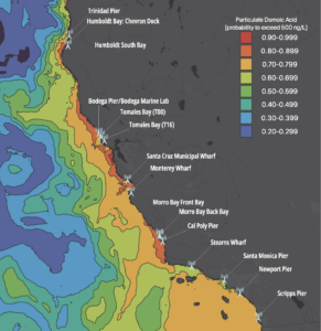
STARTED FEB 2025: Algal Bloom Effects Hundreds of Marine Mammals & Seabirds
Thursday, March 27, 2025 - 12:00amThe first marine mammal stranding related to this harmful algal bloom (HAB) was reported on February 21, 2025, and the currently the numbers are over 300. California Ocean Observing System Network HAB monitoring and Alert Program have pulled together their expertise and data to create this event-driven bulletin. Learn more in our flyer, most importantly […]

Save the Date – April 10 – San Diego MPA Collaborative Meeting
Monday, March 10, 2025 - 12:00am

Observing Seabirds Understanding Oceans
Thursday, January 02, 2025 - 12:00amWith funding from the National Science Foundation, Farallon Institute has created a page dedicated to seabirds as a ‘sentinel species’. Allowing scientists to observe seabirds to further our understanding of the health of the oceans.

California Multivariate Ocean Climate Indicator (MOCI) – December 2024 Update
Wednesday, December 18, 2024 - 12:00amAbove: Southern California MOCI, updated through September 2024. Large positive (red) values indicate warmer ocean conditions and weaker upwelling, which benefits Sardine recruitment. Negative (blue) values represent cooler ocean temperatures and strong upwelling, supporting a wide range of species, including kelp, copepods, krill, fish, and seabirds. The West Coast ocean conditions are highly variable, influenced […]

December SCCOOS PI Spotlight: Libe Washburn
Thursday, December 12, 2024 - 12:00amDecember’s Spotlight features SCCOOS PI, Libe Washburn and High-Frequency Radar (HFR) research! HFR is used to observe the ocean’s surface currents, with applications for oil spill response, public health monitoring, Coast Guard search and rescue efforts, and many more important community services. SCCOOS and CeNCOOS manage a network of HFRs to monitor the California coast. […]
Hiring New CalCOFI Director. Apply today!
Friday, November 15, 2024 - 12:00am
Video Highlighting Historic Investment in US Integrated Ocean Observing System
Tuesday, September 10, 2024 - 12:00amIn this video message Rachael Dempsey, NOS Deputy Assistant Administrator for Navigation, Observations, and Positioning, shares news on a historic investment in our national ocean observing system to enhance our nation’s coastal resilience.