On March 10th, 2011, a 9.0 earthquake occurred just off the east coast of Japan (see USGS report). The quake produced a tsunami that quickly hit the mainland of Japan and nearby islands, claiming lives, destroying homes and facilities including a nuclear plant. The tsunami waves spread in all directions throughout the Pacific Ocean.
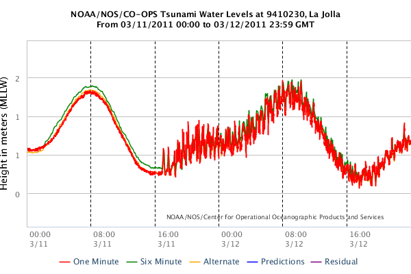
The official NOAA tide gauge at Scripps Pier recorded the tsunami
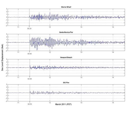
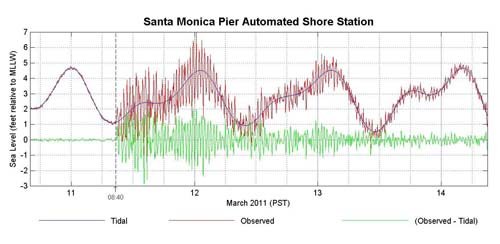
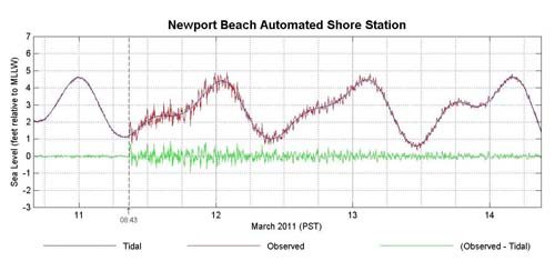
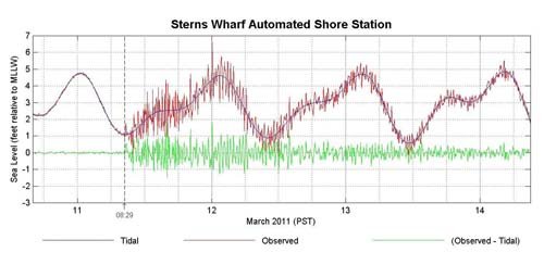
SCCOOS Automated Shore Stations captured the tsunami signal from the four stations: Scripps Pier, Newport Pier, Santa Monica Pier, and Stearns Wharf
Tsunami Recap
By Mark Coynes (Jacobsen Pilot Service, Inc)
"After the earthquake in Japan, we closely watched the NOAA Tsunami Advisories issued for Long Beach. The forecast was for the tidal surge to arrive about 0832 LT. We also found monitoring the NOAA Ports Real-Time Water level for Los Angeles helpful. We started seeing significant tidal flow just about 0940 LT. The amplitude actually increased during the first 12 hours, reaching almost 3 feet. The current period was about 20-30 minutes. We easily had currents of over 6 knots. The currents were variable with eddys setting up at choke points throughout the harbor. The most obvious flow was in and out of the middle harbor and this was met by a current flowing through the LA Harbor entrance through the Cerritos Channel out the back channel, which created significant currents middle harbor and back channel.
The pilots moving ships during the first 14 hours encountered challenges at the breakwater entrance turning into the channel as well as leaving the channel for the anchorage. The back channel with the significant flow was also challenging. A pilot reported a speed of 1.8 kts inbound past LB121 on a 7 knot dead slow bell due to current. We evacuated two tankers prior to the tidal surge arriving; one from D-6 and one from LB 121 between 0445 and 0615 LT on the 11th.
Due to the variable and unpredictable currents we held an ATC tanker out of the harbor scheduled for LB121 for 20 hours. We put an additional tug on this ship for docking. The Tsunami tidal surge took 18- 20 hours until we started to notice a reduced amplitude and a full 36 hours until the flow reduced to insignificant levels."
California Statewide Damages as of 3/14/2011
- Crescent City Harbor and 35 boats destroyed; estimates of $20-30M (preliminary) in damages.
- One person swept out to sea; possible casualty at mouth of Klamath River.
- Noyo Harbor (Fort Bragg): 400 ft pier and 2 boats damaged
- Santa Cruz Harbor: 20 boats sunk, 100 damaged; preliminary $4.5M to private boats, $10M in-harbor infrastructure including three docks.
- Morro Bay: damage to boats and docks
- Ventura Harbor: damage to several boats and a dock (8-10 hours after first wave arrival)
- Redondo Beach Harbor: large boat sunk
A few examples follow from instruments in Southern California which recorded the tsunami signal.
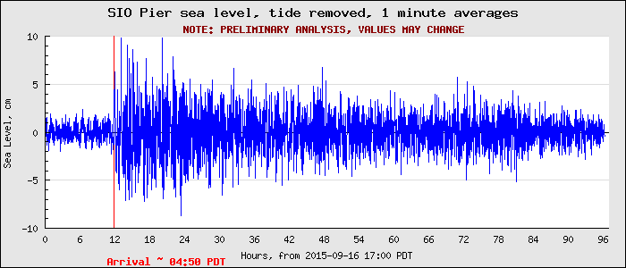
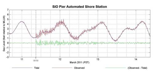
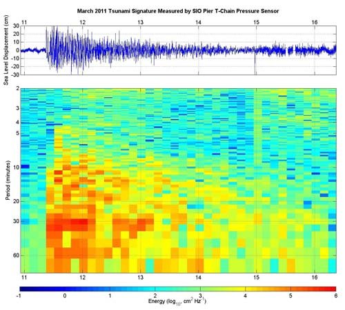
Figure: SIO Pier sea level courtesy of CDIP