2024 Stranding Event & Summertime Outlook
May 2024 – August 2024
– HAB Bulletin v2 –
The team welcomes any and all feedback on this new format of the California Harmful Algal Bloom bulletin, and extend our gratitude for your continued patience as we work through delays in development & data availability.Summary written by Dr. Clarissa Anderson, 8 October 2024
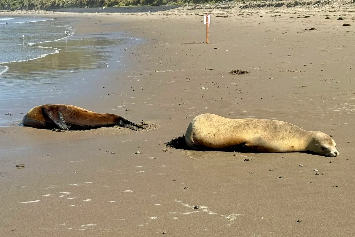
- SUMMARY: For the third year in a row, central and southern California have witnessed a large marine mammal stranding event in response to a Pseudo-nitzschia bloom and subsequent domoic acid (DA) event. This year, the strandings in California sea lions and common long-beaked dolphins (with some Northern Fur Seals) began in early July and extended to the end of August. A resurgence has been seen in September and continuing into October, but that will be covered in the next bulletin. Another remarkable harmful algal bloom event observed this summer for northern California was caused by Alexandrium spp., which produces saxitoxin and risk of Paralytic Shellfish Poisoning (PSP) from shellfish consumption. This historic bloom reached levels of Alexandrium reportedly never seen in California before this year!
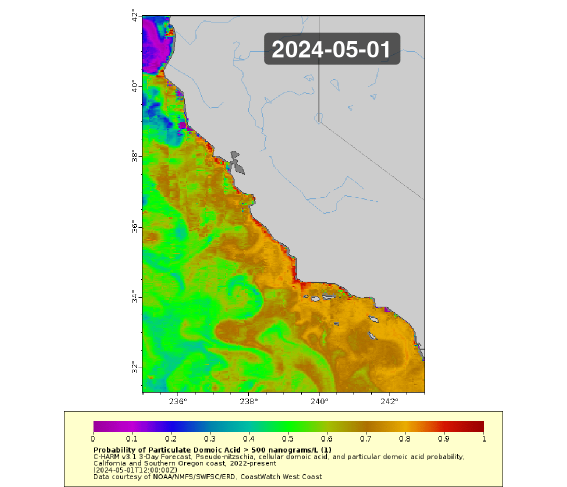
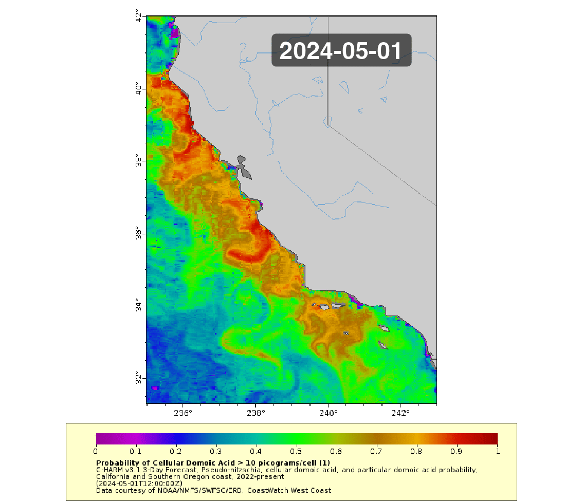
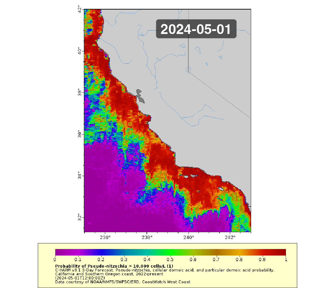
- C-HARM predictions of Pseudo-nitzschia blooms show high probabilities for much of the CA coastline from May to October, decreasing significantly 100km offshore and beyond. These high probabilities become more confined to the central coast, SF Bay to Ventura, and parts of Los Angeles and San Diego Counties in July and August. As with past years, C-HARM predicts a nexus for blooms and for particulate DA in the central CA and Santa Barbara Channel region. Probabilities of risk for pDA events were consistently high from July to August with episodes of coastal reductions in risk in June and during parts of August, however, we note a dearth of C-HARM output over the summer period due to satellite data outages and software updates. Offshore validation data are scant, but the impression given by the synoptic coverage of C-HARM is that there were potentially episodic blooms very nearshore from June through August, while the offshore zone may have experienced more persistently high bloom coverage and DA production. This is consistent with the bulk of impacts being marine mammal strandings. Cellular DA risk was skewed to favor northern California over central to southern California, which could indicate that DA production was not particularly high in places where animals were stranding, but that persistence and elevated bulk pools of DA transferred into the food web via forage fish were the primary drivers of the stranding event.
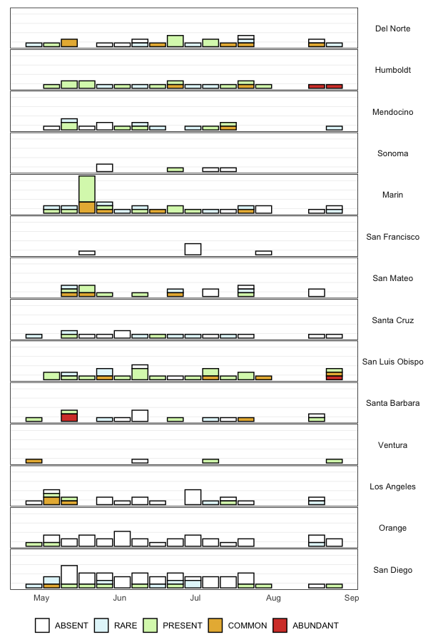
- Interestingly, and as in the past three years, HABMAP shore station monitoring picked up patchy patterns of Pseudo-nitzschia blooms, rather than a persistently high abundance of cells of either of the highly toxigenic or less toxigenic size classes over the July and August period. There were two bloom episodes of the less toxigenic Pseudo-nitzschia “delicatissima” size class where abundances well exceeded the operational bloom threshold of 10,000 cells/L at Stearns Wharf in Santa Barbara, Santa Monica Pier, and Scripps Pier in San Diego. Those levels plummeted in mid July and resurged the following week, first at Scripps Pier and then Stearns Wharf with levels from 300,000- 460,000 cells/L. For P. “seriata,” the more toxigenic size class, bloom levels were never reached at any southern California pier in early or mid July and only surpassed the bloom threshold on July 22 and July 29 at Scripps Pier. While stranded animals were concentrated in the San Luis Obispo to Santa Barbara County region, levels of both toxigenic and non-toxigenic Pseudo-nitzschia cells exceeded the bloom threshold only at Monterey Wharf, much further north, and not until Aug 14, when P. “delicatissima” abundance reached 1.5M cells/L! None of the northern California sites experienced bloom levels of Pseudo-nitzschia in July and August. Surprisingly, while animals did strand from DA toxicosis in the Los Angeles and Orange County area (including at least one fin whale!), Newport Pier never experienced bloom levels of Pseudo-nitzschia over the summer period.
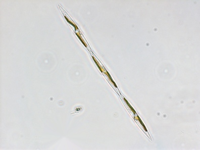
- Imaging Flow Cytobot (IFCB) real-time plankton community imagery from the same piers where weekly HABMAP monitoring occurs were analyzed with a Convolutional Neural Network (CNN) that uses machine learning to identify the plankton groups. The IFCB at Stearns Wharf captured elevated Pseudo-nitzschia cell abundance in July and again in August, but did not see a continuously high pattern throughout the DA/stranding event period. This is consistent with the intermittency observed at the HABMAP stations overall and points to the patchy nature of these blooms, as well as the offshore footprint as yet unmonitored on a routine basis. Opportunistic offshore CalCOFI sampling in the Santa Barbara Channel on Aug 6 did however reveal a phytoplankton community dominated by the more toxigenic P. “seriata” size class, corroborating the patterns being seen in C-HARM and by the preponderance of marine mammal impacts vs. nearshore shellfish toxicity impacts from DA.
- While there was generally observed to be a West Coast-wide DA event throughout the summer (see PNW HAB Bulletin), DA measurements from Cal-HABMAP were not consistently elevated or even particularly high in southern California. Non-zero hits ranged from 20-40 nanograms/L (low!) and occurred on July 1 at Santa Monica Pier, July 22 and 29 at Scripps Pier, and July 29 at Stearns Wharf. In contrast, at Santa Cruz Wharf in central California, DA levels of 1,200 ng/L (fairly high!) were measured for July 31 and August 2, with some indication of early warning in June when DA levels hit 20-30 ng/L in at SC Wharf. As mentioned above, bloom levels of Pseudo-nitzschia were observed at Monterey Wharf in mid-August, but it is important to note that DA is not routinely measured at that site nor at any of the northern California monitoring sites due to funding constraints.
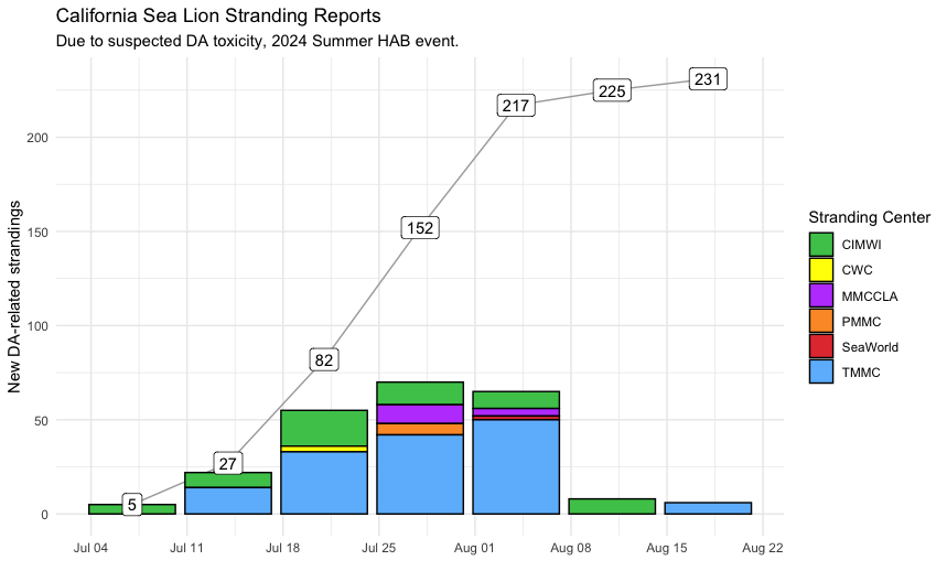
- Marine mammal strandings from suspected DA toxicosis peaked in mid-to-late July according to reports to SCCOOS from six marine mammal rescue centers, reaching 231 animals total by the end of August. This is in comparison to the over 1,000 CA Sea Lions and 100+ common long-beaked dolphins last summer. The R Shiny App linked in the Strandings tab is a real-time tool for tracking suspect DA cases as they are reported by centers, which notably are often overwhelmed and unable to collate/communicate patient lists with a rapid turnover. The majority of animals were collected and/or treated by The Marine Mammal Center (TMMC) and The Channel Islands Marine and Wildlife Institute (CIMWI) in central CA and the Santa Barbara Channel region, respectively. Los Angeles (MMCCLA CWC), Orange County (PMMC), and San Diego (SeaWorld) responded to potential DA toxicosis strandings in late July to early August, i.e. later in the event period. This delay has been seen in previous years, where the earliest strandings are in central California and Santa Barbara (and even Ventura), while the fewer animals reported for the rest of southern California lag by a week or more. Regardless, it is worth noting that the last three summer DA events have yielded stranded animals from Monterey Bay to San Diego Counties, a very large geographic range!
- The other major impact we see during DA events are those to shellfish, which is why CDPH monitors harmful algal group abundance at coastal sites and toxins in shellfish and then issues advisories for recreational shellfish harvesting based on the results of their monitoring and from HABMAP-informed guidance. Despite the widespread nature of the marine mammal stranding event, “Abundant” Pseudo-nitzschia “seriata” were never observed at any of the CDPH monitoring sites in July or August, underscoring the patchy nature of these blooms as well as the predominantly offshore characteristic. The relative abundance category “Common” was, however, recorded in Santa Barbara County on July 24, San Luis Obispo County on July 8 , July 29, and Aug 26, Marin County on July 26, Mendocino County on July 16, Humboldt County on July 21, and Del Norte County on July 15, July 24 and Aug 22. It is important to reflect on the fact that no marine mammal strandings from DA toxicosis were reported for northern California sites where these toxigenic Pseudo-nitzschia cells were reported by CDPH as “Common,” but keep in mind that many of these mammals swim long distances and might acquire toxins in regions far from where they strand. Shellfish advisories for Amnesic Shellfish Poisoning (ASP from DA poisoning) were also not entirely reflective of the cell count inventory along the coast, but did align with stranding numbers. While the entire state of California is under an annual mussel harvesting quarantine from May to October due to heightened risk of ASP, the only shellfish harvesting advisories for ASP in July and August occurred in Santa Barbara County from Aug 8 – Sep 3 and were reissued again on Sep 26 with the resurgence in DA activity (to be discussed in next bulletin).
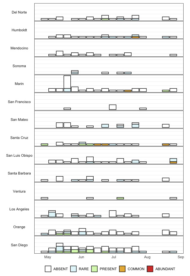
- Alexandrium spp. exceeded 10,000 cells/L at Santa Cruz Wharf in June HABMAP sampling and then exceeded 40,000 cells/L on Aug 7 and 14 at both Santa Cruz Wharf and Monterey Wharf. These are the highest levels most likely ever recorded for California (R. Kudela, pers. comm.). Cell abundances from 4,000-7,000 cells/L were observed at Cal Poly Pier (San Luis Obispo County) in late July and early September, also very high for this phytoplankton group when it comes to assessing saxitoxin and PSP risk. It is noteworthy that this PSP event occurred as far south as SLO County even though it is usually a risk seen more in northern California, and moreover, this PSP event co-occurred with a dramatic PSP event in Oregon and Washington where at least 20 people were reportedly hospitalized with PSP. In California, CDPH issued PSP advisories for recreational razor clam and shellfish harvesting in Humboldt, Del Norte, Sonoma, and Marin Counties as early as May, and these have not yet been lifted.
Particulate Domoic Acid
Particulate domoic acid (pDA) is the measurement of total domoic acid toxin that is potentially extant in a given area. This forecast provides a probability for where that concentration of toxin is predicted to exceed the threshold that classifies a Harmful Algal Bloom (> 500 nanograms per liter).
The C-HARM v3 model generates nowcast and forecasts of the probability of Pseudo-nitzschia concentrations of in excess of 10,000 cells/L, the probability of particulate domoic acid > 500 nanograms/L, and the probability of cellular domoic acid > 10 picograms/cell in California and Southern Oregon coastal waters. Inputs for the model include near real-time satellite observations, gap-filled chlorophyll a, 486nm reflectance, and 551nm reflectance fields from the S-NPP NOAA VIIRS sensor plus nowcast and forecast data of surface salinity, sea surface temperature, and surface currents from WCOFS ROMS.
Cellular Domoic Acid
Cellular domoic acid (cDA) is the measure of total domoic acid toxin calculated per cell of Pseudo-Nitzchia. This forecast provides a probability for where those cells are expected to be producing toxin at high levels (> 10 picograms per cell).
The C-HARM v3 model generates nowcast and forecasts of the probability of Pseudo-nitzschia concentrations of in excess of 10,000 cells/L, the probability of particulate domoic acid > 500 nanograms/L, and the probability of cellular domoic acid > 10 picograms/cell in California and Southern Oregon coastal waters. Inputs for the model include near real-time satellite observations, gap-filled chlorophyll a, 486nm reflectance, and 551nm reflectance fields from the S-NPP NOAA VIIRS sensor plus nowcast and forecast data of surface salinity, sea surface temperature, and surface currents from WCOFS ROMS.
Pseudo-nitzschia
Pseudo-nitzschia is a neurotoxin producing diatom that is observed along the California Coast. Blooms of this phytoplankton can be detrimental to surrounding marine ecosystems. This forecast provides a probability for where the concentration of cells in the water exceed the threshold of a Harmful Algal Bloom ( > 10,000 cells/L).
The C-HARM v3 model generates nowcast and forecasts of the probability of Pseudo-nitzschia concentrations of in excess of 10,000 cells/L, the probability of particulate domoic acid > 500 nanograms/L, and the probability of cellular domoic acid > 10 picograms/cell in California and Southern Oregon coastal waters. Inputs for the model include near real-time satellite observations, gap-filled chlorophyll a, 486nm reflectance, and 551nm reflectance fields from the S-NPP NOAA VIIRS sensor plus nowcast and forecast data of surface salinity, sea surface temperature, and surface currents from WCOFS ROMS.
California Harmful Algal Bloom Monitoring & Alert Program
Differentiating Pseudo-nitzschia species by light microscopy is difficult. For this reason, Pseudo-nitzschia “seriata” does not refer to an actual species but rather the larger size class of Pseudo-nitzschia, which is generally a more toxigenic group of species. Alternatively, Pseudo-nitzschia “delicatissima” refers to the smaller size class that is generally non-toxigenic. The dashed line on the plots demarcates the 10,000 cells/L “bloom” threshold designated here for Pseudo-nitzschia populations only.
Data for some stations are not shown as they are not yet recorded in the public HABMAP archive.
These time series focus on data collected through the scope of this bulletin and the 12 month period that precedes it. Explore the variables and regions that make up the CalHABMAP collective dataset using the plot controls.
More information and data visualizations on the statewide HAB network and forecasting system is found on the California HABMAP website and on the SCCOOS Harmful Algal Bloom page.
Domoic acid (DA) is a potent neurotoxin produced by some diatom species of the genus Pseudo-nitzschia. Species exposed to DA can result in seizures, epilepsy, cardiomyopathy, and death depending upon the ingested dose. DA toxicosis commonly occurs in California sea lions (Zalophus californianus), presumably due to a combination of foraging behavior and seasonal movements.
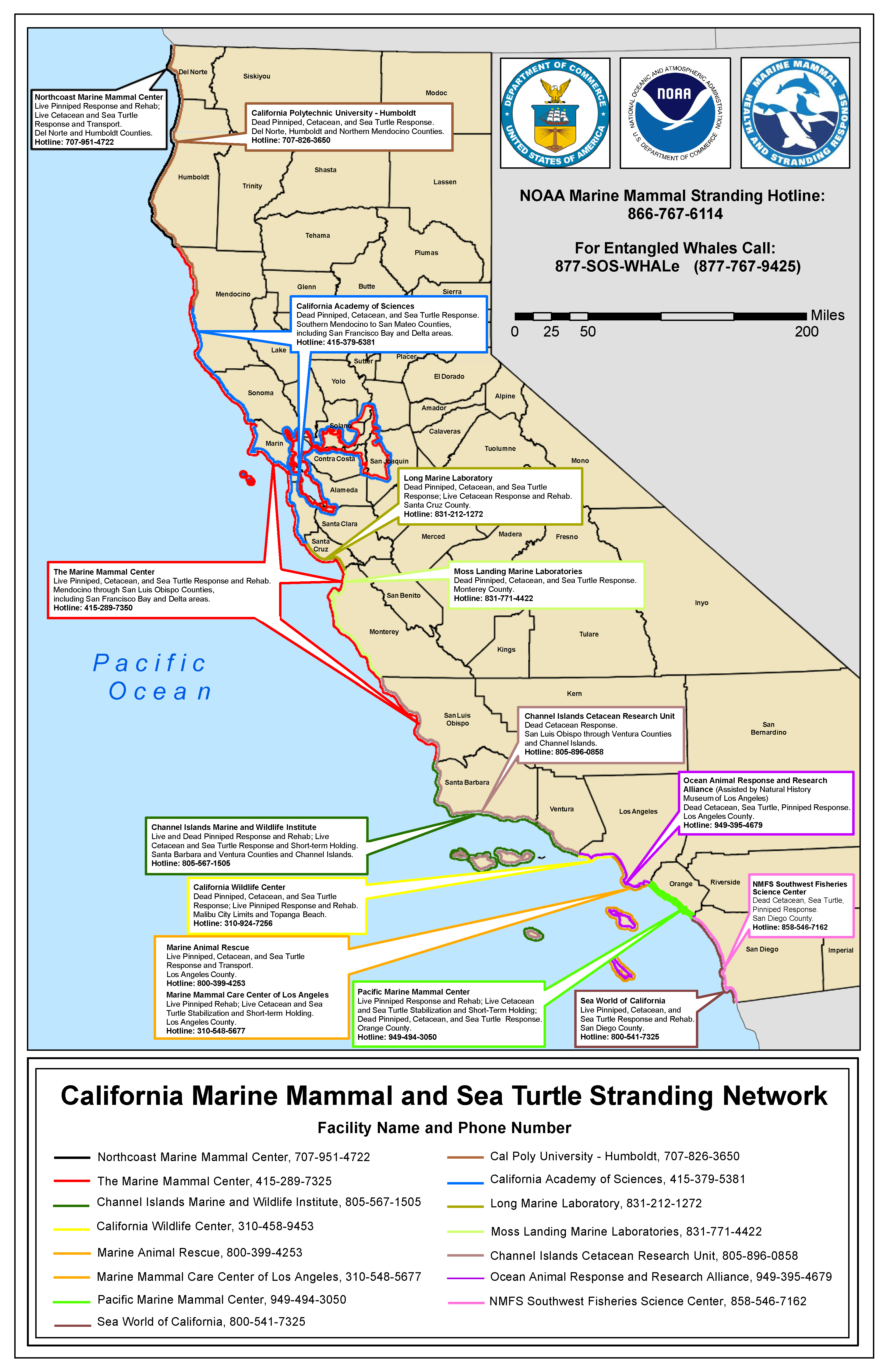
The Marine Mammal Center (TMMC), Channel Islands Marine Wildlife Institute (CIMWI), California Wildlife Center (CWC), Marine Mammal Care Center Los Angeles (MMCC-LA), Marine Animal Rescue (MAR), the Pacific Marine Mammal Center (PMMC), SeaWorld, and Southwest Fisheries Science Center (SWFSC) act like an emergency room by working to rescue and rehabilitate sick and injured marine mammals, seabirds, and sea turtles.
During event peaks, the workload of these care centers can become quickly overwhelming. The following chart is graciously collated from the dedicated members of our stranding network. Exact dates and counts during this phase are approximations based on center’s reports.
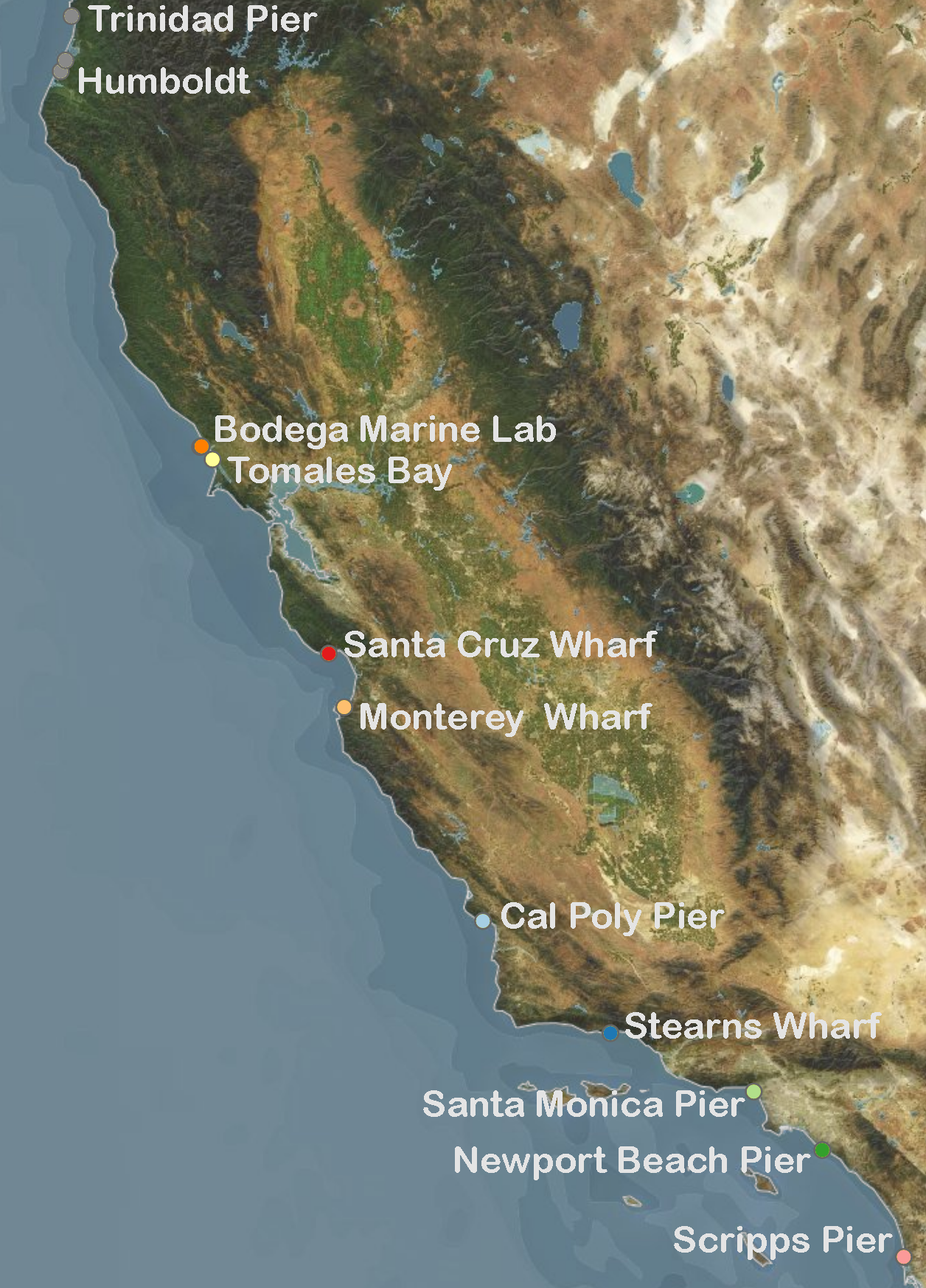
California's Marine Mammal Stranding Network Map
Each month, water samples are collected by volunteers and sent to the California Department of Public Health (CDPH) for analysis.
The relative abundance of potentially DA-producing Pseudo-nitzschia ‘seriata’ size class and PSP toxin-producing Alexandrium spp. are catalogued:
Water Sample Detailed Data
| Date_Sampled | County | Sample_Site | PN_Percent_Comp | PN_Density | AL_Percent_Comp | AL_Density |
|---|---|---|---|---|---|---|
| 2024-05-06 | San Luis Obispo | Morro Bay, Boat Launch | 1 | PRESENT | 0 | ABSENT |
| 2024-05-01 | Santa Barbara | Goleta Pier | 3 | PRESENT | 0 | ABSENT |
| 2024-05-01 | Santa Cruz | Santa Cruz, Capitola Pier | 0.5 | RARE | 1 | PRESENT |
| 2024-05-06 | San Diego | Agua Hedionda Lagoon | 0.5 | RARE | 0 | ABSENT |
| 2024-05-06 | Humboldt | Humboldt Bay, Indian Is. Ch. | 9 | PRESENT | 0 | ABSENT |
| 2024-05-07 | Marin | Point Richmond, Ferry Point | 1 | PRESENT | 0 | ABSENT |
| 2024-05-06 | Del Norte | Wilson Creek | 4 | PRESENT | 0 | ABSENT |
| 2024-05-02 | San Diego | San Diego, Mission Bay | 0.5 | RARE | 0 | ABSENT |
| 2024-05-02 | Del Norte | Hidden Beach | 0.5 | RARE | 0 | ABSENT |
| 2024-05-04 | Los Angeles | Palos Verdes, OFFSHORE | 0 | ABSENT | 0 | ABSENT |
| 2024-05-05 | Orange | Dana Pt. Harbor | 0 | ABSENT | 0 | ABSENT |
| 2024-05-09 | Orange | Newport Bay, Back Bay | 0 | ABSENT | 0 | ABSENT |
| 2024-05-03 | Orange | Bolsa Chica | 2 | PRESENT | 0.5 | RARE |
| 2024-05-13 | San Diego | Agua Hedionda Lagoon | 0 | ABSENT | 0 | ABSENT |
| 2024-05-17 | Santa Cruz | Santa Cruz Wharf | 9 | PRESENT | 0 | ABSENT |
| 2024-05-02 | Ventura | Ventura, Port Hueneme Pier | 20 | COMMON | 0 | ABSENT |
| 2024-05-16 | Marin | Drakes Bay, Chimney Rock LBS | 2 | PRESENT | 0 | ABSENT |
| 2024-05-13 | Humboldt | Humboldt Bay, Indian Is. Ch. | 2 | PRESENT | 0 | ABSENT |
| 2024-05-13 | Marin | Tomales Bay, Lease #M430-15 | 0.5 | RARE | 0 | ABSENT |
| 2024-05-06 | Marin | Tomales Bay, Lease #M430-15 | 0.5 | RARE | 0 | ABSENT |
| 2024-05-13 | San Luis Obispo | Morro Bay, Boat Launch | 2 | PRESENT | 0 | ABSENT |
| 2024-05-20 | Humboldt | Humboldt Bay, Indian Is. Ch. | 2 | PRESENT | 0 | ABSENT |
| 2024-05-10 | San Diego | Pacific Beach Pier | 0.5 | RARE | 0 | ABSENT |
| 2024-05-20 | San Luis Obispo | Morro Bay, Boat Launch | 2 | PRESENT | 0 | ABSENT |
| 2024-05-20 | San Diego | Agua Hedionda Lagoon | 2 | PRESENT | 0 | ABSENT |
| 2024-05-21 | Marin | Tomales Bay, Lease #M430-15 | 1 | PRESENT | 0 | ABSENT |
| 2024-05-13 | Mendocino | Mendocino, Noyo Harbor | 4 | PRESENT | 0 | ABSENT |
| 2024-05-13 | Del Norte | Wilson Creek | 15 | COMMON | 0 | ABSENT |
| 2024-05-15 | Santa Cruz | Santa Cruz Wharf | 0.5 | RARE | 0 | ABSENT |
| 2024-05-17 | San Diego | San Diego, Mission Bay | 0 | ABSENT | 0.5 | RARE |
| 2024-05-17 | Santa Barbara | Santa Barbara, Mohawk Reef | 70 | ABUNDANT | 0 | ABSENT |
| 2024-05-15 | San Diego | Imperial Beach Pier | 0 | ABSENT | 0.5 | RARE |
| 2024-05-15 | San Diego | San Diego Bay, U.S. Navy Pier | 0 | ABSENT | 0.5 | RARE |
| 2024-05-15 | San Luis Obispo | Port San Luis, Diablo Cove | 0.5 | RARE | 0 | ABSENT |
| 2024-05-17 | Santa Barbara | Santa Barbara Ch., Naples Pt | 9 | PRESENT | 0 | ABSENT |
| 2024-05-17 | Orange | Bolsa Chica | 0 | ABSENT | 1 | PRESENT |
| 2024-05-14 | San Mateo | Pacifica Pier | 9 | PRESENT | 0 | ABSENT |
| 2024-05-10 | Orange | Bolsa Chica | 7 | PRESENT | 0 | ABSENT |
| 2024-05-08 | Mendocino | Mendocino, Noyo Harbor | 0 | ABSENT | 0 | ABSENT |
| 2024-05-12 | Los Angeles | Point Dume, offshore | 10 | COMMON | 0 | ABSENT |
| 2024-05-11 | San Luis Obispo | Cayucos Pier | 3 | PRESENT | 0 | ABSENT |
| 2024-05-13 | Mendocino | Point Arena Pier | 0.5 | RARE | 0 | ABSENT |
| 2024-05-11 | Los Angeles | Palos Verdes Rocky Pt Offshore | 27 | COMMON | 0.5 | RARE |
| 2024-05-24 | Marin | GFNMS, Marin Line 2W | 1 | PRESENT | 0 | ABSENT |
| 2024-05-22 | Santa Cruz | Santa Cruz Wharf | 0 | ABSENT | 0 | ABSENT |
| 2024-05-20 | San Diego | La Jolla, Scripps Pier | 0 | ABSENT | 0 | ABSENT |
| 2024-05-06 | San Diego | La Jolla, Scripps Pier | 17 | COMMON | 0.5 | RARE |
| 2024-05-13 | San Diego | La Jolla, Scripps Pier | 9 | PRESENT | 1 | PRESENT |
| 2024-05-21 | Orange | San Clemente Pier | 0 | ABSENT | 1 | PRESENT |
| 2024-05-21 | Humboldt | Gold Bluffs Beach | 5 | PRESENT | 0 | ABSENT |
| 2024-05-22 | Mendocino | Mendocino, Noyo Harbor | 0 | ABSENT | 0 | ABSENT |
| 2024-05-08 | Los Angeles | Santa Monica Bay, 3501 | 6 | PRESENT | 0.5 | RARE |
| 2024-05-09 | Los Angeles | Santa Monica Bay, 3201 | 30 | COMMON | 0 | ABSENT |
| 2024-05-10 | Los Angeles | Santa Monica Bay, 3901 | 0 | ABSENT | 0.5 | RARE |
| 2024-05-15 | Santa Barbara | Goleta Pier | 68 | ABUNDANT | 0 | ABSENT |
| 2024-05-17 | Los Angeles | Palos Verdes Rocky Pt Offshore | 5 | PRESENT | 0 | ABSENT |
| 2024-05-14 | Del Norte | Hunter Rock, north | 25 | COMMON | 0 | ABSENT |
| 2024-05-17 | Orange | Newport Bay, Back Bay | 0 | ABSENT | 0 | ABSENT |
| 2024-05-18 | San Diego | Oceanside Harbor | 0 | ABSENT | 0 | ABSENT |
| 2024-05-22 | San Diego | Imperial Beach Pier | 0 | ABSENT | 1 | PRESENT |
| 2024-05-22 | San Diego | San Diego Bay, U.S. Navy Pier | 0 | ABSENT | 0.5 | RARE |
| 2024-05-25 | San Mateo | Pillar Point Harbor | 1 | PRESENT | 0 | ABSENT |
| 2024-05-24 | Orange | Bolsa Chica | 0 | ABSENT | 0.5 | RARE |
| 2024-05-22 | Orange | Newport Bay, Back Bay | 0 | ABSENT | 0 | ABSENT |
| 2024-05-25 | Marin | GFNMS, San Francisco Line 6W | 10 | COMMON | 0 | ABSENT |
| 2024-05-24 | Marin | GFNMS, Marin Line 2E | 1 | PRESENT | 0.5 | RARE |
| 2024-05-24 | Marin | GFNMS, Marin Line 2E | 5 | PRESENT | 0 | ABSENT |
| 2024-05-24 | San Francisco | Oakland, Jack London Aquatic | 0 | ABSENT | 0 | ABSENT |
| 2024-05-27 | Mendocino | Point Arena Pier | 0 | ABSENT | 0 | ABSENT |
| 2024-05-28 | Humboldt | Humboldt Bay, Indian Is. Ch. | 0.5 | RARE | 0 | ABSENT |
| 2024-05-20 | Marin | GFNMS, Marin Line 4E | 5 | PRESENT | 0 | ABSENT |
| 2024-05-28 | San Diego | La Jolla, Scripps Pier | 0 | ABSENT | 1 | PRESENT |
| 2024-05-18 | Humboldt | Trinidad Pier | 6 | PRESENT | 0 | ABSENT |
| 2024-05-16 | Mendocino | Mendocino, Noyo Harbor | 7 | PRESENT | 0 | ABSENT |
| 2024-05-19 | San Mateo | GFNMS, San Mateo Line 8W | 4 | PRESENT | 0 | ABSENT |
| 2024-05-30 | San Mateo | Pacifica Pier | 5 | PRESENT | 0 | ABSENT |
| 2024-05-28 | San Diego | Imperial Beach Pier | 0.5 | RARE | 0 | ABSENT |
| 2024-05-29 | Santa Cruz | Santa Cruz Wharf | 0 | ABSENT | 0 | ABSENT |
| 2024-05-28 | San Luis Obispo | Morro Bay, Boat Launch | 0.5 | RARE | 0 | ABSENT |
| 2024-05-18 | San Mateo | GFNMS, San Mateo Line 10E | 12 | COMMON | 0 | ABSENT |
| 2024-05-25 | Marin | GFNMS, San Francisco Line 6-EX | 25 | COMMON | 0 | ABSENT |
| 2024-05-28 | San Diego | Agua Hedionda Lagoon | 0 | ABSENT | 0 | ABSENT |
| 2024-05-30 | Marin | Richmond, Marina Bay Harbor | 2 | PRESENT | 0 | ABSENT |
| 2024-05-28 | Marin | Tomales Bay, Lease #M430-15 | 0.5 | RARE | 0 | ABSENT |
| 2024-05-30 | Sonoma | Bodega Harbor, USCG Dock | 0 | ABSENT | 0 | ABSENT |
| 2024-05-29 | San Luis Obispo | San Luis Obispo, Cal Poly Pier | 0.5 | RARE | 0 | ABSENT |
| 2024-05-31 | Marin | Drakes Bay, Chimney Rock LBS | 10 | COMMON | 0 | ABSENT |
| 2024-05-28 | Del Norte | Wilson Creek | 0 | ABSENT | 0 | ABSENT |
| 2024-05-29 | Santa Barbara | Goleta Pier | 0.5 | RARE | 0.5 | RARE |
| 2024-05-19 | San Mateo | GFNMS, San Mateo Line 7E | 10 | COMMON | 0 | ABSENT |
| 2024-05-20 | Marin | GFNMS, Marin Line N4-WN | 25 | COMMON | 0 | ABSENT |
| 2024-05-27 | San Diego | Pacific Beach Pier | 2 | PRESENT | 1 | PRESENT |
| 2024-05-29 | Mendocino | Mendocino, Noyo Harbor | 0 | ABSENT | 0 | ABSENT |
| 2024-05-29 | Sonoma | Kashia Coastal Reserve | 0 | ABSENT | 0.5 | RARE |
| 2024-05-30 | Orange | Newport Bay, Back Bay | 0 | ABSENT | 0 | ABSENT |
| 2024-05-18 | San Mateo | GFNMS, San Mateo Line 10W | 0.5 | RARE | 0 | ABSENT |
| 2024-05-21 | Marin | GFNMS, Marin Line N2WN | 4 | PRESENT | 0 | ABSENT |
| 2024-05-31 | Orange | Bolsa Chica | 0 | ABSENT | 0 | ABSENT |
| 2024-05-30 | Los Angeles | Catalina Island, Avalon Bay | 0 | ABSENT | 0 | ABSENT |
| 2024-05-31 | Los Angeles | Palos Verdes Rocky Pt Offshore | 0 | ABSENT | 0.5 | RARE |
| 2024-05-20 | Marin | GFNMS, Marin Line 4W | 2 | PRESENT | 0.5 | RARE |
| 2024-05-31 | San Luis Obispo | Port San Luis, Diablo Cove | 15 | COMMON | 0 | ABSENT |
| 2024-06-03 | Humboldt | Humboldt Bay, Indian Is. Ch. | 3 | PRESENT | 0 | ABSENT |
| 2024-06-03 | Marin | Tomales Bay, Lease #M430-15 | 0.5 | RARE | 0 | ABSENT |
| 2024-06-03 | San Diego | Agua Hedionda Lagoon | 0 | ABSENT | 6 | PRESENT |
| 2024-06-03 | San Luis Obispo | Morro Bay, Boat Launch | 5 | PRESENT | 0 | ABSENT |
| 2024-06-10 | San Luis Obispo | Morro Bay, Boat Launch | 0 | ABSENT | 0.5 | RARE |
| 2024-06-02 | Orange | Santa Catalina Ch., Plt Eureka | 0 | ABSENT | 0 | ABSENT |
| 2024-06-03 | San Diego | La Jolla, Scripps Pier | 0 | ABSENT | 0.5 | RARE |
| 2024-06-03 | Del Norte | Wilson Creek | 0 | ABSENT | 0 | ABSENT |
| 2024-06-05 | Santa Cruz | Santa Cruz Wharf | 0 | ABSENT | 0.5 | RARE |
| 2024-06-17 | San Diego | Agua Hedionda Lagoon | 0 | ABSENT | 0 | ABSENT |
| 2024-06-06 | San Diego | Imperial Beach Pier | 0 | ABSENT | 0 | ABSENT |
| 2024-06-07 | Orange | Bolsa Chica | 0 | ABSENT | 0 | ABSENT |
| 2024-06-08 | Orange | Dana Pt. Harbor | 0 | ABSENT | 0.5 | RARE |
| 2024-06-10 | Mendocino | Mendocino, Noyo Harbor | 8 | PRESENT | 0 | ABSENT |
| 2024-06-10 | Humboldt | Humboldt Bay, Indian Is. Ch. | 0.5 | RARE | 0 | ABSENT |
| 2024-06-10 | San Diego | Agua Hedionda Lagoon | 0 | ABSENT | 1 | PRESENT |
| 2024-06-10 | Marin | Tomales Bay, Lease #M430-15 | 1 | PRESENT | 0 | ABSENT |
| 2024-06-12 | Santa Cruz | Santa Cruz Wharf | 0.5 | RARE | 2 | PRESENT |
| 2024-06-12 | Santa Barbara | Goleta Pier | 0 | ABSENT | 0 | ABSENT |
| 2024-06-13 | Ventura | Ventura, Port Hueneme Pier | 0 | ABSENT | 0 | ABSENT |
| 2024-06-13 | Marin | Richmond, Marina Bay Harbor | 0.5 | RARE | 0 | ABSENT |
| 2024-06-17 | Humboldt | Humboldt Bay, Indian Is. Ch. | 7 | PRESENT | 0 | ABSENT |
| 2024-06-17 | San Luis Obispo | Morro Bay, Boat Launch | 1 | PRESENT | 0 | ABSENT |
| 2024-06-17 | Marin | Tomales Bay, Lease #M430-15 | 15 | COMMON | 0 | ABSENT |
| 2024-06-04 | Orange | Newport Bay, Back Bay | 0 | ABSENT | 0.5 | RARE |
| 2024-06-23 | San Mateo | Pillar Point Harbor | 10 | COMMON | 0.5 | RARE |
| 2024-06-26 | San Mateo | Pillar Point Harbor | 0.5 | RARE | 0.5 | RARE |
| 2024-06-24 | Humboldt | Humboldt Bay, Indian Is. Ch. | 1 | PRESENT | 0 | ABSENT |
| 2024-06-19 | Santa Cruz | Santa Cruz Wharf | 3 | PRESENT | 15 | COMMON |
| 2024-06-04 | Mendocino | Mendocino, Noyo Harbor | 2 | PRESENT | 0 | ABSENT |
| 2024-06-10 | Del Norte | Wilson Creek | 0.5 | RARE | 0 | ABSENT |
| 2024-06-04 | Los Angeles | Santa Monica Pier | 0 | ABSENT | 0 | ABSENT |
| 2024-06-02 | Santa Cruz | Santa Cruz Wharf | 0 | ABSENT | 1 | PRESENT |
| 2024-06-24 | San Luis Obispo | Morro Bay, Boat Launch | 0 | ABSENT | 0 | ABSENT |
| 2024-06-10 | San Diego | La Jolla, Scripps Pier | 1 | PRESENT | 1 | PRESENT |
| 2024-06-16 | San Diego | San Diego, Mission Bay | 0.5 | RARE | 0 | ABSENT |
| 2024-06-17 | Del Norte | Wilson Creek | 10 | COMMON | 0 | ABSENT |
| 2024-06-18 | Mendocino | Mendocino, Noyo Harbor | 0.5 | RARE | 0 | ABSENT |
| 2024-06-26 | Sonoma | Bodega Harbor, USCG Dock | 1 | PRESENT | 0 | ABSENT |
| 2024-06-24 | San Diego | Agua Hedionda Lagoon | 0 | ABSENT | 0 | ABSENT |
| 2024-06-24 | Marin | Tomales Bay, Lease #M430-15 | 3 | PRESENT | 0 | ABSENT |
| 2024-06-27 | Del Norte | Wilson Creek | 2 | PRESENT | 2 | PRESENT |
| 2024-06-11 | Del Norte | Hunter Rock, north | 0 | ABSENT | 0 | ABSENT |
| 2024-06-12 | San Luis Obispo | Cayucos Pier | 4 | PRESENT | 0 | ABSENT |
| 2024-06-11 | San Luis Obispo | Port San Luis, Diablo Cove | 6 | PRESENT | 0 | ABSENT |
| 2024-06-13 | Los Angeles | Catalina Island, Avalon Bay | 0 | ABSENT | 0 | ABSENT |
| 2024-06-07 | Santa Barbara | Santa Barbara Ch., Naples Pt | 0 | ABSENT | 0 | ABSENT |
| 2024-06-10 | Mendocino | Point Arena Pier | 0.5 | RARE | 0 | ABSENT |
| 2024-06-27 | Marin | Drakes Bay, Chimney Rock LBS | 8 | PRESENT | 0 | ABSENT |
| 2024-06-13 | San Diego | Imperial Beach Pier | 0 | ABSENT | 0 | ABSENT |
| 2024-06-13 | San Mateo | Pacifica Pier | 8 | PRESENT | 0 | ABSENT |
| 2024-06-12 | Santa Barbara | Santa Cruz Is., Prisoners Hrbr | 0 | ABSENT | 0 | ABSENT |
| 2024-06-10 | San Luis Obispo | Morro Bay, North T-Pier | 7 | PRESENT | 0 | ABSENT |
| 2024-06-10 | San Diego | Pacific Beach Pier | 0 | ABSENT | 0 | ABSENT |
| 2024-06-12 | Orange | San Clemente Pier | 0 | ABSENT | 0 | ABSENT |
| 2024-06-30 | Orange | Dana Pt. Harbor | 0 | ABSENT | 0 | ABSENT |
| 2024-06-30 | San Francisco | Oakland, Jack London Aquatic | 0 | ABSENT | 0 | ABSENT |
| 2024-06-17 | San Diego | La Jolla, Scripps Pier | 0 | ABSENT | 0 | ABSENT |
| 2024-06-26 | Santa Cruz | Santa Cruz Wharf | 0.5 | RARE | 20 | COMMON |
| 2024-06-21 | Los Angeles | Palos Verdes Rocky Pt Offshore | 0 | ABSENT | 0.5 | RARE |
| 2024-06-26 | Orange | Newport Bay, Back Bay | 0 | ABSENT | 0 | ABSENT |
| 2024-06-25 | Del Norte | Wilson Creek | 5 | PRESENT | 0 | ABSENT |
| 2024-06-28 | Orange | Bolsa Chica | 0 | ABSENT | 0 | ABSENT |
| 2024-06-26 | Santa Barbara | Goleta Pier | 2 | PRESENT | 0 | ABSENT |
| 2024-06-27 | Humboldt | Trinidad Pier | 10 | COMMON | 0.5 | RARE |
| 2024-06-21 | Orange | Bolsa Chica | 0 | ABSENT | 0 | ABSENT |
| 2024-06-26 | San Diego | San Diego Bay, U.S. Navy Pier | 0.5 | RARE | 0 | ABSENT |
| 2024-06-24 | Del Norte | Hunter Rock, north | 5 | PRESENT | 0 | ABSENT |
| 2024-06-26 | San Diego | Imperial Beach Pier | 0 | ABSENT | 0 | ABSENT |
| 2024-06-24 | San Diego | La Jolla, Scripps Pier | 1 | PRESENT | 1 | PRESENT |
| 2024-06-13 | Los Angeles | Catalina Island, Avalon Bay | 0 | ABSENT | 0 | ABSENT |
| 2024-06-14 | Orange | Bolsa Chica | 0 | ABSENT | 0 | ABSENT |
| 2024-06-14 | Santa Barbara | Santa Barbara Ch., Naples Pt | 0 | ABSENT | 0.5 | RARE |
| 2024-07-03 | San Francisco | Emeryville Pier | 0 | ABSENT | 0 | ABSENT |
| 2024-07-01 | San Luis Obispo | Morro Bay, Boat Launch | 1 | PRESENT | 0 | ABSENT |
| 2024-07-01 | Humboldt | Humboldt Bay, Indian Is. Ch. | 0.5 | RARE | 0.5 | RARE |
| 2024-07-01 | Marin | Tomales Bay, Lease #M430-15 | 3 | PRESENT | 0 | ABSENT |
| 2024-07-01 | San Diego | Agua Hedionda Lagoon | 0 | ABSENT | 0 | ABSENT |
| 2024-07-08 | Marin | Tomales Bay, Lease #M430-15 | 0.5 | RARE | 0 | ABSENT |
| 2024-07-08 | San Diego | Agua Hedionda Lagoon | 0 | ABSENT | 0 | ABSENT |
| 2024-07-08 | San Luis Obispo | Morro Bay, Boat Launch | 2 | PRESENT | 0 | ABSENT |
| 2024-07-08 | Humboldt | Humboldt Bay, Indian Is. Ch. | 0.5 | RARE | 0 | ABSENT |
| 2024-07-05 | San Francisco | Emeryville Pier | 0 | ABSENT | 0 | ABSENT |
| 2024-07-01 | Del Norte | Wilson Creek | 0.5 | RARE | 0 | ABSENT |
| 2024-07-03 | San Diego | San Diego Bay, U.S. Navy Pier | 0.5 | RARE | 0 | ABSENT |
| 2024-07-01 | Mendocino | Point Arena Pier | 0.5 | RARE | 0 | ABSENT |
| 2024-07-01 | San Diego | La Jolla, Scripps Pier | 0.5 | RARE | 0.5 | RARE |
| 2024-07-16 | Sonoma | Bodega Harbor, USCG Dock | 0 | ABSENT | 0.5 | RARE |
| 2024-07-08 | San Luis Obispo | Cayucos Pier | 10 | COMMON | 0 | ABSENT |
| 2024-07-08 | Del Norte | Hunter Rock, north | 4 | PRESENT | 0 | ABSENT |
| 2024-07-08 | San Diego | La Jolla, Scripps Pier | 0 | ABSENT | 0.5 | RARE |
| 2024-07-10 | Sonoma | Kashia Coastal Reserve | 0 | ABSENT | 0 | ABSENT |
| 2024-07-11 | San Luis Obispo | Port San Luis, Diablo Cove | 6 | PRESENT | 0 | ABSENT |
| 2024-07-03 | Santa Cruz | Santa Cruz Wharf | 0.5 | RARE | 0.5 | RARE |
| 2024-07-10 | San Diego | San Diego Bay, U.S. Navy Pier | 0 | ABSENT | 0 | ABSENT |
| 2024-07-12 | Orange | San Clemente Pier | 0 | ABSENT | 0 | ABSENT |
| 2024-07-12 | Orange | Bolsa Chica | 0 | ABSENT | 0 | ABSENT |
| 2024-07-15 | Humboldt | Humboldt Bay, Indian Is. Ch. | 1 | PRESENT | 0.5 | RARE |
| 2024-07-15 | Marin | Tomales Bay, Lease #M430-15 | 0 | ABSENT | 20 | COMMON |
| 2024-07-15 | San Diego | Agua Hedionda Lagoon | 0 | ABSENT | 0 | ABSENT |
| 2024-07-09 | Del Norte | Wilson Creek | 4 | PRESENT | 0.5 | RARE |
| 2024-07-10 | Santa Cruz | Santa Cruz Wharf | 0 | ABSENT | 0 | ABSENT |
| 2024-07-10 | Santa Barbara | Goleta Pier | 0.5 | RARE | 0.5 | RARE |
| 2024-07-15 | San Luis Obispo | Morro Bay, Boat Launch | 4 | PRESENT | 0 | ABSENT |
| 2024-07-05 | Orange | Bolsa Chica | 0 | ABSENT | 0 | ABSENT |
| 2024-07-06 | Los Angeles | Palos Verdes Rocky Pt Offshore | 0 | ABSENT | 0 | ABSENT |
| 2024-07-07 | Mendocino | Mendocino, Noyo Harbor | 1 | PRESENT | 0 | ABSENT |
| 2024-07-07 | Los Angeles | Catalina Island, Avalon Bay | 0.5 | RARE | 0 | ABSENT |
| 2024-07-03 | Los Angeles | Catalina Island, Avalon Bay | 0 | ABSENT | 0 | ABSENT |
| 2024-07-03 | Los Angeles | Santa Monica Pier | 0 | ABSENT | 0 | ABSENT |
| 2024-07-03 | Los Angeles | Catalina Island, Abalone Pt. | 0 | ABSENT | 0 | ABSENT |
| 2024-07-02 | Orange | Newport Bay, Back Bay | 0 | ABSENT | 0 | ABSENT |
| 2024-07-22 | Marin | Tomales Bay, Lease #M430-15 | 0.5 | RARE | 0 | ABSENT |
| 2024-07-17 | Santa Cruz | Santa Cruz Wharf | 0.5 | RARE | 0 | ABSENT |
| 2024-07-10 | San Mateo | Bean Hollow State Beach | 0 | ABSENT | 0.5 | RARE |
| 2024-07-10 | San Mateo | Pillar Point Harbor | 0 | ABSENT | 0 | ABSENT |
| 2024-07-22 | Humboldt | Humboldt Bay, Indian Is. Ch. | 4 | PRESENT | 0.5 | RARE |
| 2024-07-22 | San Luis Obispo | Morro Bay, Boat Launch | 8 | PRESENT | 0.5 | RARE |
| 2024-07-22 | San Diego | Agua Hedionda Lagoon | 0 | ABSENT | 0 | ABSENT |
| 2024-07-11 | Ventura | Ventura, Port Hueneme Pier | 3 | PRESENT | 2 | PRESENT |
| 2024-07-23 | San Luis Obispo | San Luis Obispo, Cal Poly Pier | 1 | PRESENT | 0.5 | RARE |
| 2024-07-29 | Marin | Point Richmond, Ferry Point | 0 | ABSENT | 0 | ABSENT |
| 2024-07-14 | Los Angeles | Catalina Island, OFFSHORE | 0 | ABSENT | 0 | ABSENT |
| 2024-07-19 | Orange | Bolsa Chica | 0 | ABSENT | 0 | ABSENT |
| 2024-07-26 | Marin | Drakes Bay, Chimney Rock LBS | 20 | COMMON | 0 | ABSENT |
| 2024-07-22 | San Diego | La Jolla, Scripps Pier | 6 | PRESENT | 0.3 | RARE |
| 2024-07-29 | Humboldt | Humboldt Bay, Indian Is. Ch. | 2 | PRESENT | 0 | ABSENT |
| 2024-07-29 | San Luis Obispo | Morro Bay, Boat Launch | 35 | COMMON | 0 | ABSENT |
| 2024-07-29 | Marin | Tomales Bay, Lease #M430-15 | 0 | ABSENT | 0 | ABSENT |
| 2024-07-24 | Santa Barbara | Goleta Pier | 20 | COMMON | 0 | ABSENT |
| 2024-07-24 | Santa Cruz | Santa Cruz Wharf | 0 | ABSENT | 0 | ABSENT |
| 2024-07-29 | San Francisco | Oakland, Jack London Aquatic | 0 | ABSENT | 0 | ABSENT |
| 2024-07-25 | San Mateo | Bean Hollow State Beach | 0 | ABSENT | 0.5 | RARE |
| 2024-07-25 | San Mateo | Pillar Point | 0.5 | RARE | 0.5 | RARE |
| 2024-07-24 | Del Norte | Wilson Creek | 10 | COMMON | 0.5 | RARE |
| 2024-07-15 | Del Norte | Hidden Beach | 15 | COMMON | 0 | ABSENT |
| 2024-07-15 | Los Angeles | Palos Verdes, OFFSHORE | 6 | PRESENT | 0 | ABSENT |
| 2024-07-15 | San Diego | Pacific Beach Pier | 0 | ABSENT | 0 | ABSENT |
| 2024-07-29 | San Diego | La Jolla, Scripps Pier | 3 | PRESENT | 0.3 | RARE |
| 2024-07-16 | Mendocino | Mendocino, Noyo Harbor | 10 | COMMON | 0 | ABSENT |
| 2024-07-23 | San Mateo | Pacifica Pier | 1 | PRESENT | 0 | ABSENT |
| 2024-07-27 | Los Angeles | Palos Verdes Rocky Pt Offshore | 0 | ABSENT | 0 | ABSENT |
| 2024-07-26 | Orange | Bolsa Chica | 0 | ABSENT | 0 | ABSENT |
| 2024-07-24 | San Diego | Imperial Beach Pier | 0 | ABSENT | 0 | ABSENT |
| 2024-07-24 | San Diego | San Diego Bay, U.S. Navy Pier | 0 | ABSENT | 0 | ABSENT |
| 2024-07-23 | Orange | Dana Pt. Harbor | 0 | ABSENT | 0 | ABSENT |
| 2024-07-22 | Del Norte | Hidden Beach | 0.5 | RARE | 0 | ABSENT |
| 2024-07-17 | San Diego | San Diego Harbor, Pier 159 | 0 | ABSENT | 0 | ABSENT |
| 2024-07-21 | Humboldt | Trinidad Head | 30 | COMMON | 10 | COMMON |
| 2024-07-22 | Del Norte | Hunter Rock, north | 0 | ABSENT | 0 | ABSENT |
| 2024-07-16 | Santa Barbara | Santa Cruz Is., Prisoners Hrbr | 0 | ABSENT | 0 | ABSENT |
| 2024-07-16 | Mendocino | Mendocino, Noyo Harbor | 3 | PRESENT | 0 | ABSENT |
| 2024-08-21 | Humboldt | Trinidad Pier | 97.5 | ABUNDANT | 0.5 | RARE |
| 2024-08-26 | San Luis Obispo | Port San Luis, Diablo Cove | 89 | ABUNDANT | 0.5 | RARE |
| 2024-08-26 | Humboldt | Humboldt Bay, Indian Is. Ch. | 80 | ABUNDANT | 0 | ABSENT |
| 2024-08-22 | Del Norte | Hunter Rock, north | 30 | COMMON | 0 | ABSENT |
| 2024-08-26 | San Luis Obispo | Morro Bay, Boat Launch | 10 | COMMON | 10 | COMMON |
| 2024-08-20 | Santa Barbara | Santa Cruz Is., Prisoners Hrbr | 7 | PRESENT | 0 | ABSENT |
| 2024-08-30 | San Luis Obispo | Cayucos Pier | 3 | PRESENT | 0.5 | RARE |
| 2024-08-26 | Ventura | Ventura, Port Hueneme Pier | 1 | PRESENT | 0 | ABSENT |
| 2024-08-26 | San Diego | La Jolla, Scripps Pier | 1 | PRESENT | 0.5 | RARE |
| 2024-08-26 | Marin | Tomales Bay, Lease #M430-05 | 0.5 | RARE | 0 | ABSENT |
| 2024-08-23 | Los Angeles | Manhattan Beach Pier | 0.5 | RARE | 0 | ABSENT |
| 2024-08-23 | Orange | Bolsa Chica | 0.5 | RARE | 0 | ABSENT |
| 2024-08-26 | Mendocino | Point Arena Pier | 0.5 | RARE | 0 | ABSENT |
| 2024-08-26 | Del Norte | Wilson Creek | 0.5 | RARE | 0 | ABSENT |
| 2024-08-20 | Marin | Marina Bay Boat Launch | 0 | ABSENT | 1 | PRESENT |
| 2024-08-21 | Santa Cruz | Santa Cruz Wharf | 0 | ABSENT | 10 | COMMON |
| 2024-08-27 | Marin | Drakes Bay, Chimney Rock LBS | 0 | ABSENT | 0 | ABSENT |
| 2024-08-20 | San Mateo | Bean Hollow State Beach | 0 | ABSENT | 0 | ABSENT |
| 2024-08-20 | San Mateo | Pillar Point Harbor | 0 | ABSENT | 0 | ABSENT |
| 2024-08-21 | Santa Barbara | Goleta Pier | 0 | ABSENT | 0 | ABSENT |
| 2024-08-23 | San Diego | Oceanside Harbor | 0 | ABSENT | 0 | ABSENT |
| 2024-08-23 | Orange | San Clemente Pier | 0 | ABSENT | 0 | ABSENT |
| 2024-08-22 | Orange | Newport Bay, Back Bay | 0 | ABSENT | 0 | ABSENT |
| 2024-08-28 | Santa Cruz | Santa Cruz Wharf | 0 | ABSENT | 0 | ABSENT |
| 2024-08-20 | Del Norte | Hunter Rock, north | 0 | ABSENT | 0 | ABSENT |
| 2024-08-30 | Orange | Bolsa Chica | 0 | ABSENT | 0 | ABSENT |
| 2024-08-29 | Orange | Newport Bay, Back Bay | 0 | ABSENT | 0 | ABSENT |
| 2024-08-24 | Los Angeles | Point Dume, offshore | 0 | ABSENT | 0 | ABSENT |
Percent composition categories help us look at phytoplankton trends across an entire region to evaluate risk of biotoxin presence. Many other factors contribute to our evaluation of risk in an area. These samples are posted for informational purposes only. They are not intended to inform the public of the presence or lack of risk. For the latest health advisory information, see the CDPH Health Advisory Map below.
____
Razor Clam consumption advisory issued due to domoic acid levels and risk of amnesic shellfish poisoning.
____
Bivalve shellfish consumption advisory issued after detection of natural occurring paralytic shellfish poisoning toxins.
Santa Cruz & Sonoma
Bivalve shellfish consumption advisory issued after detection of natural occurring paralytic shellfish poisoning toxins.
____
Bivalve shellfish consumption advisory issued after detection of natural occurring paralytic shellfish poisoning toxins.
& Humboldt County
Bivalve shellfish consumption advisory due to domoic acid levels and risk of amnesic shellfish poisoning.
& Humboldt County
Bivalve shellfish consumption advisory due to domoic acid levels and risk of amnesic shellfish poisoning.
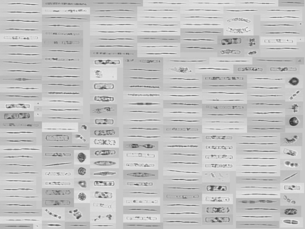
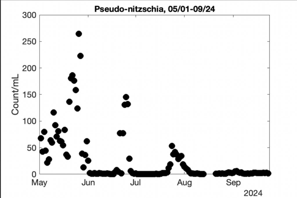
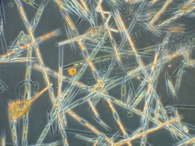
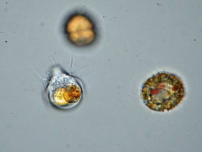
Above: (left) An image bin dominated by Pseudo-nitzschia chains from Stearns Wharf in Santa Barbara, June 26 2024. (right) A plot of Pseudo-nitzschia count per mL at the same Stearns Wharf sampling site, derived from machine learning classifiers over these image bins.
A network of Imaging FlowCytobots (IFCBs) continuously photographs particles, such as plankton, in the water. Using machine learning, plankton species can be automatically identified. This will help improve the ability to detect and respond to Harmful Algal Blooms, including the ability to assess conditions that may lead to toxin production or blooms of toxin-producing algae.
Additional images and data are available on the IFCB dashboard.
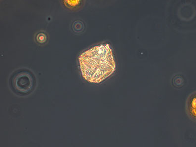
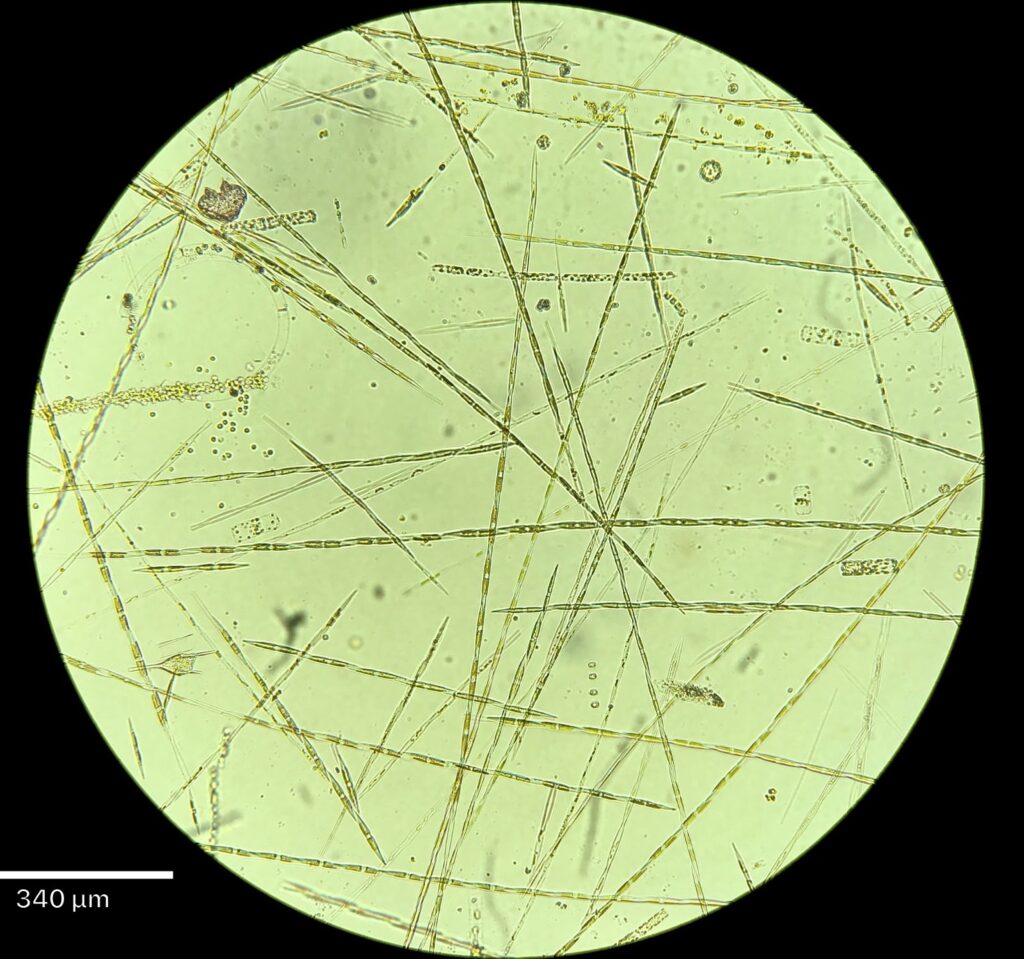
Below, a high resolution microscopy image from offshore sample in the Santa Barbara Channel on August 6th, found Pseudo nitzschia “seriata” dominating a large diatom bloom in the channel.
California HAB Bulletin
All data and reports have been synthesized by SCCOOS for the California Harmful Algal Bloom Monthly Bulletin.
Data Access & Resources:
C-HARM, NOAA CoastWatch ERDDAP
Toxic Phytoplankton Observations, CDPH
Imaging FlowCytoBot Dashboard
CalHABMAP Datasets, SCCOOS ERDDAP